When this article is being written, missiles and drone attacks have resumed a few hours after the declaration of ceasefire between India and Pakistan. It is obvious that today many types of modern technology are used in such wars, but all that technology is beyond our reach. Let’s talk about a technique that is really useful for us! Of course, it is not used for war.
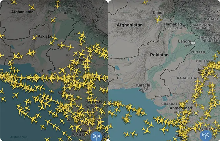
Watch the two screenshots of the side specially taken for ‘TechnoWorld’, where you can see the location of several aircraft flying in the sky of both neighboring countries at that time. The first screenshot was taken on 6 May 2025 at 10:50 PM IST. That is, before India started its attack in Pakistan -occupied Kashmir and Pakistan under ‘Operation Sindoor’.
Pakistan on 22 April. Two days after India took extremely strict steps against Pakistan after the first incident, Pakistan had to lose the ‘fare’ income from those airlines to use the airspace!). So, in the night screenshot of May 6, countless aircraft can be seen flying over Pakistan.
The second screenshot is on 10 May 2025. That day Pakistan had shut down its airspace for all airlines. That is why the sky of Pakistan is a dry desert, a desert that can be said, ‘Not a single bird rotates in the sky’! Both these screenshots are taken from the website called ‘Flightradar 24’ (https://www.flightradar24.com/) (also have Apple and Android apps). Seva posted on the X platform on May 10 that till date the Flietrdar 24 Seva is not tracking any aircraft in the Pakistani airspace. When the issue was accused of helping Pakistan of helping Pakistan, the Flordarrdar service had to clarify that “NOTAM (notice to airmen – very important information sent to pilots about changes or risks in the airy area system), Pakistan’s airspace has been shut down, if there is not a single aircraft in the sky, what do we track?”
In fact, after India accused Pakistan of using civil aircraft as a shield, Pakistan has been forced to shut down its aircraft for all air traffic.
You must have seen all these things on TV channels recently, as well as reference pictures from Flightradar 24. If you are eager about this service, let’s talk a little more-including how this service is useful for sons and daughters living abroad and parents living in the country!
Before we talk more about Flitterdar 24 service, which keeps an eye on thousands of aircraft flying in the sky around the world in real time, let’s talk a little about how the planes are usually monitored in the sky.
Radar system
Air traffic controllers have been using radar since the 1950s, and it is still the main means of monitoring aircraft. The use of radar had begun during World War II before that.
There are two types of radars, primary and secondary. The primary radar sends electromagnetic waves to the sky, which appears as a point on the radar screen when colliding with an object – such as aircraft. That point has not been identified in this. Primary radar is mostly used for military air protection.
The secondary radar is widely used in civil aviation. The secondary radar also sends electromagnetic waves, but it stops these waves and sends a message back with its identity.
To get these messages, it is necessary to have radar station on the ground, about 300 kilometers. This is the reason that when an aircraft descends from the ground and goes above the sea, it does not hold the secondary radar (that is why the Malaysian aircraft crashed in March 2014 had ‘disappeared’ and had to long discovered its debris).
ADS-B
Another relatively new technology to monitor the aircraft is Ads-B (automatic dependent monitoring-pradition). In this technique, a different type of transponder, which is usually attached under the aircraft, keeps sending radio waves that can be controlled by the cockpit. The ADS-B transponder also sends GPS information about the aircraft, flight number, speed, if the aircraft is climbing up, etc., which is determined based on various satellites. This technique can provide more information at a much lower cost than the secondary radar.
This technique is relatively new and most aircraft manufacturers have started installing Ads-B transponders in their aircraft, but have not yet been widely used under air traffic control. Why ? Experts say that security in the aviation industry is taken so seriously that it takes years to implement any changes related to it.
Apart from this, pilots are in contact with air traffic control and ground stations through radio communication. They can also stay in contact with the ground through a system called aircraft communications addressing and reporting system (ACARS), which almost acts like our SMS.
Flightradar24 flying
Today, more than two lakh aircraft fly daily from the ground. Half of these are commercial or private aircraft, air ambulances, government or military aircraft etc., and the rest are commercial, cargo and charter -type aircraft. Most of the aircraft have transponders that use ads-B technology mentioned above.
This technology is also fond of this world. Two enthusiastic youths of Sweden gained a little more interest in keeping an eye on flying aircraft in the air. Like the enthusiasts of Ham Radio, they can legally get the ADB-S signal from the aircraft after installing a special type of receiver (they require a license to forward someone else). The two friends launched an amateur project in 2006 to create a network of Ads-B receivers in North and Central Europe. He began showing this data on the website with attractive scenes. Within three years, he opened the entire project and enabled anyone with Ads-B receiver to add his data to this network.
In short, at present, about two lakh flights are monitored daily on this web service. For this, it receives data from about 40,000 receivers connected to each other. It is the largest network of its kind in the world.
Make your mobile ‘radar’
If you go to this site or its app, you will see a map of the world, in which we can choose the field of interest. In parts like Europe or North America you will see endless grounds like an ants bill. If you see with a little patience, you will be able to see all the aircraft moving a little bit. The system of the site connects the available data related to the aircraft to Google Maps.
If you click on any aircraft, you will see information on the left panel of the screen, such as which airline is on, which flight is on, its journey route is shown, how much height it is, and how much is its speed (all these data are public data that has been provided keeping in mind the security). This also shows how many kilometers a distance has been covered by the aircraft in its total journey.
The aircraft flying in the air can be seen in different scenes by clicking on the 3D view link in the panel. If your internet connection and computer capacity is good, you can see this scene very well. Of course, the location of the aircraft on the map is correct, but its views are not real, only an illusion has been created on the map.
If you buy the Pro version of this app, you can search for specific flights. It also gives fun of the agranded reality view, that is, according to the company’s claim, if an aircraft is passing up, then the flightradar 24 app ‘recognizes’ and gives us full details when the flightradar 24 apps on the mobile camera and turning it towards the aircraft!
Finally, if the young sons and daughters of your family live abroad and parents live in the country, your son or daughter will be getting faster while returning home from the plane. You can also track their trip on this site!
Pune: High court’s ‘no stay’ on illegal school, clearing the way for demolition